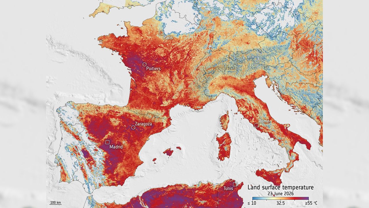
Europe's Sentinel-3 satellite has captured thermal data revealing the full extent of a June heat wave that proved deadly across the continent. The satellite, part of the European Copernicus program, recorded surface temperature measurements that allowed researchers to map and quantify the atmospheric conditions responsible for the extreme weather event.
Sentinel-3 carries advanced radiometers that detect infrared radiation, enabling scientists to measure land and sea surface temperatures with high precision from orbit. This data provides a comprehensive view of heat distribution patterns across Europe that ground-based weather stations alone cannot capture. The satellite's thermal imagery helps researchers understand how heat waves develop, intensify, and persist over large geographic areas.
The heat wave's severity and geographic reach became apparent through satellite visualization. Data from the mission allows meteorologists and climate scientists to correlate surface temperatures with mortality records and health impacts reported across affected regions. Such satellite observations serve as critical tools for assessing climate extremes and their human consequences.
Sentinel-3 observations contribute to Europe's climate monitoring infrastructure and inform heat wave response strategies. The satellite's continuous monitoring helps establish baseline temperatures and identify anomalies, essential work as heat waves become more frequent and intense. Scientists use this data to improve weather prediction models and better anticipate future extreme events.
The Copernicus program, operated jointly by the European Commission and the European Space Agency, relies on multiple Earth observation satellites to track environmental changes. Sentinel-3's thermal data complements other satellite measurements of atmospheric conditions, precipitation, and cloud cover. This integrated approach provides researchers with detailed, actionable information about heat wave dynamics.
Satellite-based heat monitoring faces limitations. Clouds can obscure thermal signatures, and spatial resolution, while excellent, cannot capture fine-scale temperature variations within cities. Ground-truth data from weather stations remains essential for validating satellite measurements. Despite these constraints, Earth observation satellites fundamentally changed how scientists study extreme weather events and document